By Allison Flynn
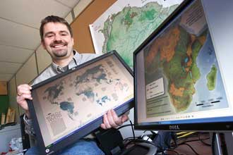
Bernhard Lehner is a hydrographer whose work is about to go global. Fusing the fields of hydrology and cartography, he has created a one-of-a-kind map of the world’s rivers that is included as a pull-out in the April 2010 “Fresh Water” Issue of National Geographic, the iconic magazine that’s read in 32 languages by more than 8 million people every month.
Six years ago, while working on a watershed conservation project with the World Wildlife Fund (WWF), Lehner and his colleagues hit a snag. They were looking to characterize freshwater habitats within a remote region of the Amazon Basin covering parts of Peru, Bolivia and Brazil. The river maps of the three countries that existed weren’t good enough because, when pieced together, they didn’t exactly match up at the borders. Lehner’s solution proved to be the catalyst for a wildly ambitious project: to be the first to build a comprehensive, seamless, digital map of the world’s rivers, in unprecedented resolution and detail.
Using data gathered in 2000 by NASA’s Shuttle Radar Topography Mission (SRTM) – a space shuttle flight dedicated to measuring the topography of the Earth’s surface – as his starting point, Lehner eventually produced a high-resolution map of that small portion of the Amazon Basin. “It worked well, and colleagues then asked if we could repeat this for the entire Amazon,” Lehner recalled. “So the Amazon map was the next step. Another colleague saw that one and asked if we could do it for all of South America. And so the map of South America happened.”
The project that WWF dubbed “HydroSHEDS” (Hydrological data and maps based on SHuttle Elevation Derivatives at multiple Scales) kept growing from there, computing power was ramped-up and Lehner and his team began writing code used to eventually run through all the continents. Lehner left WWF for a professorship in Global Hydrology in the Geography Department at McGill four years ago and has been working steadily on the map, with continued support from WWF, ever since.
While it is not the first global river map in existence – one may be found in any atlas – it is the first high-resolution, seamless global river map that is also available in a digital, pixel-based format. “It’s produced using a GIS software package that’s pixel-based – something that hydrological [computer] models need,” explained Lehner. “So, researchers are excited about it. If you just look at the map, it seems very similar to those in an atlas. But the format, the data and the way it’s provided, is entirely different.”
Another element unique to this map is that it can be coupled with other maps or hydrological models. This enables Lehner to provide information on attributes like river flow and to distinguish large from small rivers – a feature that traditional maps have not been able to illustrate easily in the past. “The rivers on most paper maps are simple lines, and the cartographers have to manually distinguish, one by one, whether they represent a little stream or the mighty Amazon,” said Lehner. “For the first time we have a product for which we can automatically produce attributes that show river size, length, watershed boundaries, or even more complex features such as how many people live upstream of a river reach.”
While the global river map is being formally released in a paper format in National Geographic, HydroSHEDS remains a work-in-progress as Lehner and his team continually add more attributes like river names and classes, the outlines of sub-basins and catchment areas and links to other layers such as lakes and reservoirs.
But the map already appears to have limitless practical applications. When asked, Lehner admits he doesn’t know where to begin. From conservation biology and ecology to climate modelling to irrigation and food production, the map is in high demand. The map data are free and available for download, and Lehner estimates that since the data sets were made available online, there have been about a thousand downloads a month.
As of March 30, when National Geographic hits the stands, one could guess that Lehner may see a spike in downloads as the paper pull-out iteration of the HydroSHEDS map
goes mainstream. “Personally, I really like that this scientific product will get such broad attention,” said Lehner.
“It confirms that geography contributes to issues that the public is interested in … That it’s important beyond academia.” He added: “National Geographic usually produces very colourful maps. This one’s nearly monochromatic…A little bit of text, no photos, no images. Their designers insisted that the rivers alone be the focus. We’ve never had a proper look at the rivers globally in good quality before. And now we have.”